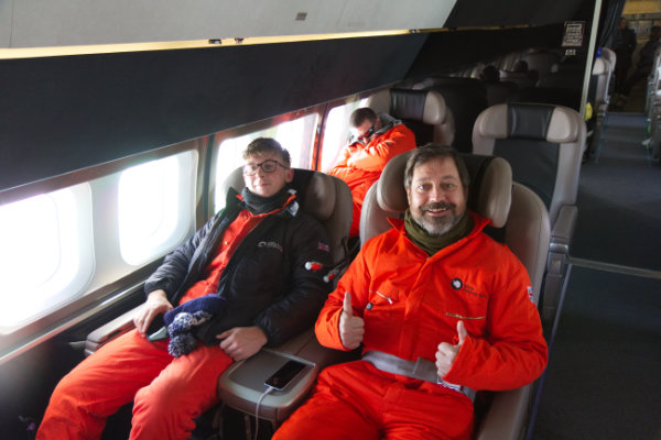
Luckily the flight down to Novo from Cape Town went ahead as planned on Sunday morning (10th) and I arrived at Novo 6 hours later. The upgrade to the 757 was even better than expected, the plane ALCI ended up chartering was fitted out to full on VIP spec with super comfy leather seat and ooodles of leg room.
Arriving at Novo the luxury ended but that didn’t matter, we were all too excited to be in Antarctica. Getting off the plane, the Novo staff helped us off the stairs to make sure our Antarctic adventure didn’t end instantly by slipping on the highly polished blue ice runway.
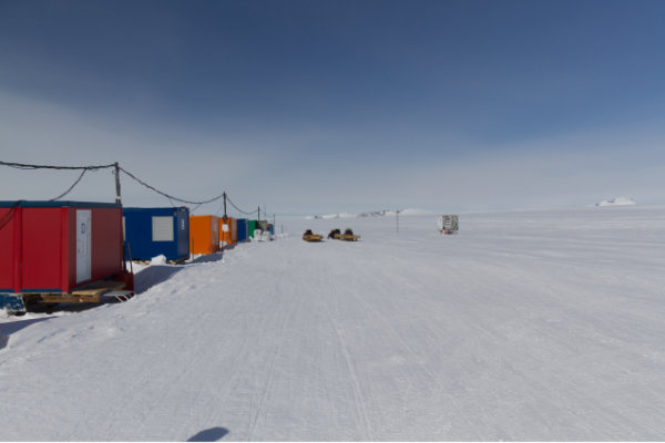
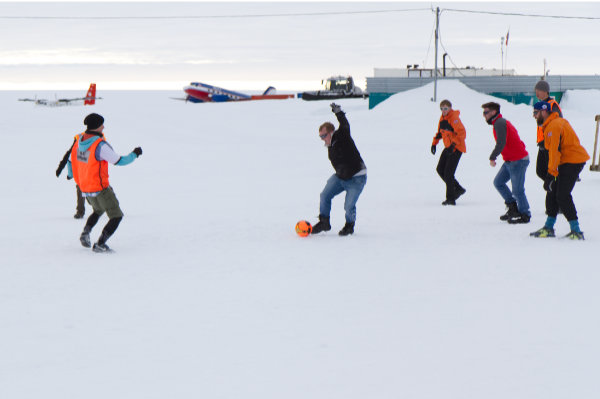
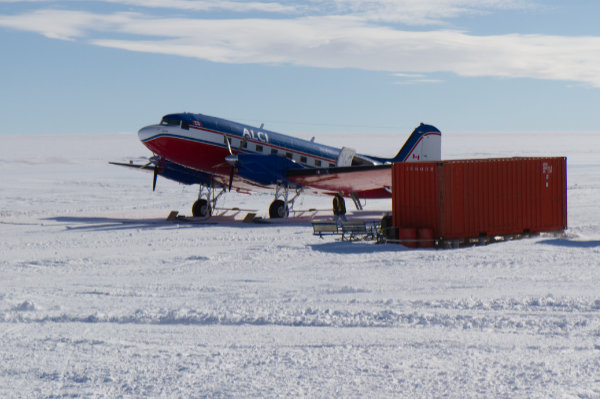
12 lucky people were whisked straight off to a waiting Basler BT-67 - an upgraded 1940’s DC3 - to continue on to Halley. I was left there with 17 others pointed and in the direct on a couple of porta-cabins next to the runway where we’d spend the next couple of nights - that was plenty. The highlight of my stay at Novo was the UK (BAS) vs Russia & Argentina (Novo staff) football match. Watching people play football in giant Baffin boots is hilarious.
While at breakfast on Tuesday morning we were told our flight to Halley would be leaving in 30 minutes, and 25 minutes later we were in the air on the way to Halley.
Arriving at Halley was amazing, as the plane came in to land the famous string of modules came in to view and once landed we were greeted by Al, the Halley Station Leader, and welcomed to Antarctica before heading off to the station in a Snow-Cat for a late morning Smoko - an an extra mid-morning meal between Breakfast and Lunch (we have 5 meals a day down here).
With Antarctica being a rather cold, hostile place, we all have to go through an induction when we first arrive on station so this is how I spent the rest of Tuesday and most of Wednesday. Some of this is really obvious stuff like a tour of the modules and where you’ll be sleeping, other parts are about how to stay safe outside or when riding a Skidoo.
Once induction was through, it was on to some work, but I’ll leave that for another post.
As I write this I’m sitting in Cape Town, South Africa, waiting to fly first to Novo and then to Halley Research Station in Antarctica.
Strictly speaking, I suppose you could say the journey began back in July when I went for an Interview with British Antarctic Survey (BAS) in Cambridge and the following day they were nice enough to offer me the job of Summer ICT Engineer at Halley.
On Monday this week the real journey began, I said goodbye to friends and jumped on a train down to Heathrow Airport to take the first of 3 flights to Halley.
The flights to Halley from Cape Town are operated by a company called ALCI, they operate flights from Cape Town to a number of different countries stations via a blue ice runway just next to the Russian Novolazarevskaya Station in Queen Maud Land, Antarctica (conveniently shortened to Novo). For a flight to go ahead you need a few days of good conditions in both Novo, and the other stations people are flying to and from. To make sure they don’t miss the all important weather windows they get all the passengers down to Cape Town a couple of days early.
The weather in Antarctica has been poor this last week, delaying my flight down by a couple of days. On the plus side this has given me a few days to kill, so I’ve been down to see the penguins at Boulders Beach, visited the Cape of Good Hope and been on a mini safari.
If the weather decides to play ball, I’ll be boarding a Boeing 757 (their normal Ilyushin IL 76 isn’t available) down to Novo early tomorrow morning and then a Basler BT 76 (an upgraded DC3) to Halley.
Expect the odd picture or two to appear once I’ve got the right cables, as I cleverly checked them in for the Antarctic flight a couple of days ago.
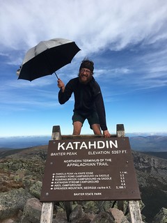
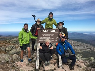
If you’ve read any of my blog posts in the last year you’ll know I planned to hike all 2,189 miles of the Appalachian Trail from Springer Mountain in Georgia to Mount Katahdin in Maine. If you read my last post you’ll even know I made it about a third of the way before going silent. Well I’m happy to say that at about lunchtime on 29th September 2016 I reached Katahdin’s summit.
My original intention had been to put up a new blog post about once a week along the whole journey. However, as I progressed along the trail, publishing the posts and uploading photos became more and more of a chore. That last post took 4 or 5 hours to publish, only about 1 of those hours was spent writing, the rest of the time was spent fighting the rubbish hotel wifi. Given that I typically only stopped for between half a day to a whole day in town I decided I didn’t want to waste my time fighting technology so gave up blogging and stuck with just posting on twitter (in hindsight I really should’ve posted this paragraph back then).
If you’d like to see how I progressed along the trail take a look at the map, you can hover over points to see the dates.
What now?
That’s a great question, and the honest answer at this moment is I’m not completely sure. Since finishing I’ve been dinghy sailing in Greece with friends and visited family up in Scotland, I surpose it’s now time to do something sensible and stop spending my savings.
More pictures to follow, the Flickr app decided not to upload most of them.
After a couple of people mentioned it I realised I forgot to mention I had a trail name a few weeks back. On the trail I’m now Pancake. I was sitting in camp one night with some Americans and we were talking about food and it sort of stuck.
Day 68: Pearisburg day off
Tuesday 24th May
0 miles
My original plan was to head out about lunch time but when I popped to the post office my letter hadn’t arrived but the lady at the post office said to expect it tomorrow. The hardware stores gas delivery also hadn’t shown up so I ended up staying a second night.
Day 69: Campsite
Wednesday 25th May
8.5 miles
20,586 steps
263 floors
After grabbing a quick breakfast I had to wait for the post office and hardware store to open. The post office was no hassle at all, I finally had my credit card - thanks Mum. However by 10:30 there was still no sign of the hardware store opening, luckily a guy just arriving in to the motel had a spare gas canister and gave it to me so I was able to head off at about 11.
It was s really hot day with little water so by the time we made it uphill to the campsite after 8.5 miles both 007 and I decided to call it a day. The fact that it was the last water for 11 miles making the decision easy.
Day 70: Bailey Gap Shelter
Thursday 26th May
14.9 miles
35,544 steps
340 floors
Back to a normal length day, the first half looked nice and flat in the guide but it lived up to its nickname of the book of lies as the entire morning was up and down over rocks.
That afternoon we passed The Captains - a local guy who lets hikers camp in his garden - which is reached by a swing seat on a zip wire over a river. He even keeps a fully stocked fridge of fizzy drinks for hikers to help themselves to on his back porch.
From the Captains place it was less than three miles too the shelter, but they were some amazingly steep miles making for a significantly later than expected finish.
Day 71: Camping spot off VA630
Friday 27th May
17.9 miles
45,678 steps
395 floors
Having walked uphill the night before we were already up by the ridge line which started with a gentle climb for a few miles and plenty of loose rocks.
After a steep descent I stopped at War Spur shelter for lunch where some hikers who’d stayed at The Captains the previous night were cooking fish over the fire.
A long ascent and descent filled the afternoon bringing me to Laurel Creek shelter around 5. 007 and I decided it was a little early to stop for the day so decided to head for the next water source just by the VA630 road. A few hours later we get there and run in to Sneaky Pete and Costa Rica who had just hitched to town and back, while chatting a German lady joined us who was also looking to camp there, her name was Moonfire. A very short way up the hill Sneaky Pete found us a campsite and after a small hiccup where I pitched my tent under a dead tree so had to move it we settled in for a wet evening around the campfire.
Day 72: Trout Creek campsite
Saturday 28th May
18 miles
43,008 steps
413 floors
This was the day I lost 007, Moonfire and I got slightly carried away distance wise and he only made it to the previous water stop.
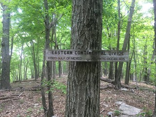
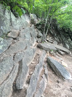
The day started with a reasonably short but steep uphill past Keffer Oak - the largest Oak tree on the southern AT - followed by flat looking terrain, however for the next few miles it was solely walking along a rocky ridge line. I stopped for a snack at the fork down to Sarver Hollow shelter and had a chat with Sonja and Bern (a German couple without trail names) mostly about whether any of us could be bothered with the mile round trip for water (we couldn’t). A further 4 miles of walking along the rocky ridge led to some slow going, especially as it was a long way down if I fell. At the end of the ridge section is a sign letting you know the ridge is the Eastern Continental Divide.
I made it to Niday shelter for about 3 and after spending a while pondering what to do Moonfire mentioned she was heading another 9 miles to Trout Creek (the only water source other than 2 miles away) which seemed as good an idea as any.
The first couple of miles were nice and easy but then it was up 1,500 foot in 2 miles and high temperatures with little tree cover. Luckily some kind soul had put a bench at the top of the hill and I just lay there resting for about 5 minutes before attempting the wide flatish trail ahead.
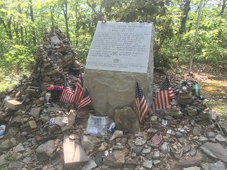
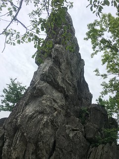
At the end of the flat section was a short side trail to the Audie Murphy monument. Audie Murphy was the most decorated American soldier in World War II and died in a plane crash near that spot many years later.
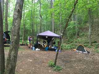
Just as I started the downhill after the monument I ran in to three guys heading south who mentioned there was trail magic at the bottom of the hill. Given the time I was expecting a cooler full of coke or something along those lines but it was still enough for me to speed up my descent. Just under 4 miles later as I got to the bottom of the hill I could see people sitting around a fire and a gazebo with grill, seats and small crowd of hikers. Under the gazebo I discovered Grandma and Old Goat doing large scale trail magic. They were giving out hot dogs, soup, sandwiches, soda and beer to any hungry hikers who came near. They’re a lovely retired couple whose daughter hiked the trail a couple of years ago and ever since they’ve been doing trail magic a few times a year. This time they’d been there since Tuesday feeding about 50 hikers a day.
Once she heard my trail name Grandma mentioned they’d be doing pancakes for breakfast which was perfect as I’d planned to camp there anyway.
Day 73: Catawaba Mountain Shelter
Sunday 29th May
15.8 miles
42,261 steps
526 floors
The day got off to a slightly later start than planned as just as I was about to leave camp I was offered more breakfast - scrambled eggs this time - as a follow up to my first breakfast of grits and pancakes. The aim for the day was to either reach the shelter just before McAfee Knob or to reach McAfee Knob in time for sunset and then stop at the next shelter.
Once I’d said thank you and goodbye to Grandma and Old Goat the first 5 miles of the day were uphill and it was pretty warm up to Cove Mountain where there was a short side trail to Dragons Tooth.
After returning from Dragons Tooth the guide just shows a couple of miles downhill. What it fails to show is that the first half mile or so involved heading down a rocky path with 6 foot drops in places. After that it flattens out to a reasonably pleasant downhill with just a few rocky patches.
Conveniently the trail crosses a road a few miles after Dragons Tooth and there’s a petrol station 0.2 miles away where I stopped for drinks and ice cream with some other hikers and caught up with Moonfire.
From Catawaba Creek at the bottom of the hill it again looked easy, a short uphill followed by reasonably flat terrain, in reality it was non stop ups and downs and by the time I reached Johns Spring shelter with Moonfire it had started to rain too. That made the decision easy, we headed on another mile to Catawaba Mountain shelter and called it a night. The surprising thing was that Johns Spring shelter was completely empty and Catawaba only had 1 person plus 2 in a tent, I was expecting them to be full of hikers waiting to summit McAfee Knob in the morning.
Day 74: Campsite by Hay Rock
Monday 30th May
13.2 miles
35,510 steps
331 floors
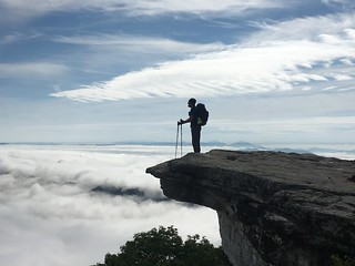
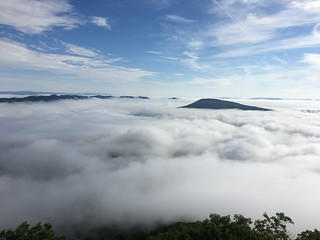
The highlight of the week was 1.7 miles in to the day, arriving at McAfee Knob. Standing on McAfee Knob is probably the most common photo on the trail, everyone sits or stands on the same bit of rock and has their photo taken from the left (Kathadin would be more popular but less people reach there). As you can see I’m highly original and have the same photo too 😀.
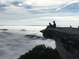
When I reached McAfee Knob with Moonfire the valleys below were full of clouds which added some real atmosphere to the views, and made you realise just how high up the edge was. An up side of camping so close the night before was we beat all the day hikers so it was lovely and peaceful up there. After about 45 minutes Moonfire headed off (she wanted to get in to town) and I just sat there enjoying the view for almost an hour more.
After McAfee Knob I headed less than a mile downhill to Campbell Shelter for an early lunch as the next stretch of trail had seen some unwelcome bear activity. Hanging bear bags of food were taken 3 days on the run as was somebody’s pack and people were being asked not to eat or sleep anywhere near Lamberts Meadow shelter.
With the closed shelter my original plan of a very short (8 mile) day to give 007 a chance to catch up went out of the window so I did the ups and downs past Tinker cliffs and the shelter to what the trail maintainers called a temporary campsite. In actual fact it was a fairly steeply sloped road with only a couple of flattish spots but it was my home for the night.
Day 75: Troutville / Daleville
Tuesday 31st May
4.7 miles
11,748 steps
72 floors
A short day heading in to town. Troutville and Daleville seem to merge together so I’m not quite sure which one I’m actually staying in. I woke up late, had a slow leisurely breakfast and took my time coming down the hill in to town where I met up with 007 to share a room. The landmarks in the guidebook weren’t too exciting as they’re all power lines.
Day 76: Day off in town
Wednesday 1st June
0 miles
Over the last few days all the skin has rubbed off my right heel so I’m taking an extra day off to let it heal up. I bought some shorts as my trousers were both too big and too warm - the shorts have 4” smaller waist - and soon food and then sat around by the pool all day.
Due to complete laziness and lack of organisation over the last couple of days it was about 3:30 by the time I left town. In that time I’d managed to fit in a calzone for lunch, a trip to the supermarket and failed miserably to buy new shoes from three different outfitters (they didn’t fit).
The challenge for the day was to find a nice person with a car who’d take me back to Fox Creek. After about 45 minutes or so of standing with my thumb out on the main road out of town a lovely lady stopped and offered me a lift who’d hiked the trail last year and was just back in town for trail days (pictured below).
Day 60: Partnership Shelter
Monday 16th May
14 miles
30,608 steps
294 floors
Not a bad day with plenty of ups and downs which I finished a little earlier than planned. When I got to Partnership Shelter at about 4pm Pterodactyl was just placing a pizza order from the nearby visitor centre. The thought of pizza for tea rather than dehydrated rubbish was far too tempting so I cut the day short.
Partnership shelter is by far the smartest shelter so far on the trail. It has a sink with running water, a privy with toilet paper and once the heater’s fixed a hot shower. It also, at the time that I stopped, had a resident local weirdo. He was begging for money and food and drugs off everyone, when somebody gave him Tylenol thinking he was in pain he ground it up and snorted it off the shelter log book. I don’t think anybody was sad to see the back of him the following morning.
Day 61: Campsite at Crawfish Trail
Tuesday 17th May
18.4 miles
43,124 steps
425 floors
I aimed for a slightly longer day to make up for the early finish the day before. A good day of hiking except for the last couple of miles before Atkins which were slick mud.
Around lunchtime I came to a late 1800’s single room school which various local groups had left trail magic in, in the form of fizzy drinks, snacks, toiletries and knitted hats and gloves. A couple of miles later brought the town of Atkins. At least the guide claims it’s a town I’m not convinced to petrol stations and a restaurant really qualify. On the plus side it did have a local restaurant that served cheap large burgers ideal for hikers so I stopped for dinner with some guys I’d bumped in to at the school before hiking on for about 6 more miles.
Day 62: Chestnut Knob Shelter
Wednesday 18th May
17.3 miles
41,456 steps
524 floors
A horrible day of hiking as the trail was just slick mud for q good chunk of the day.
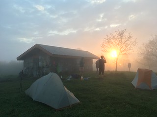
Chestnut Knob Shelter is a little unusual, it’s only the second shelter I’ve seen with four walls and a door. It’s on a big grassy hill which’d probably have quite a nice view if we hadn’t been in the cloud - however it did lead to a pretty sunset. About half the trail seemed to be here, 007, Tortuga, Constantine, Pterodactyl, Chuckles, Ranger, Norway and Thin Mint just to name a few. 15 of them ended up in the shelter designed for 8 with people sleeping under bunks, on and under the picnic table.
Day 63: Laurel Creek Campsite
Thursday 19th May
15.1 miles
38,263 miles
272 floors
Again too much mud on some of the downhills, other than that a pretty uneventful day.
A really nice campsite just over the road from Laurel Creek. A good bunch of us camped here - Chuckles and partner, Cup of Tea, 007, Tortuga, Thin Mint & her Dad and Rock City. We even had trail magic courtesy of Chuckles and partner who was visiting him for a few days. She brought beer, bread and cheese and crackers and hummus. Ideal to eat beside a roaring fire.
Day 64: Bland, Virginia
Friday 20th May
6.9 miles
16,446 steps
160 floors
A short day as I needed to stop at Bland post office to collect my new shoes. The days hike again featured mud after s steepish uphill, once I got to the gap to hitch in to Bland i bumped in to Chuckles who volunteered his other half to give me a lift - she’d just finished shuttling in Cup of Tea and Rock City - which made my journey easy.
Unfortunately the parcel was delayed so I ended up spending the night in Bland - which really does live up to its name. The motel wasn’t bad though.
Day 65: Campsite by Dismal Falls
Saturday 21st May
20.2 miles
52,845 steps
496 floors
A late start as I had to wait for the post office to open. The hike was horribly muddy all day with occasional showers. My first obstacle was getting back to the trail some 3 miles out of town. After a while of failed attempts to hitch I gave up and started walking and after a mile or so a friendly local picked me up.
The trail was reasonably flat for a good chunk of the trail but again it was horribly slippy with mud. It was also pretty boring in places with a 6.5 mile stretch without a single landmark. The next shelter was too close at 10 miles do I headed for Kimberling Creek - the next point with camping and water. When I got there the water was brown with mud - not at all appetising - due to all the recent rain so I pressed on.
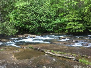
Dismal Falls was the next campsite with water and I arrived there with Tortuga after a my first 20 mile day. The falls were pretty and would be great for swimming on a nice day.
I can’t recommend doing your longest day on the first time you wear new shoes my feet hurt quite a bit.
Day 66: Docs Knob Shelter
Sunday 22nd May
15.7 miles
37,988 steps
336 floors
A purposely shorter day as my feet hurt. In the guide it looked a really easy day, mostly flat with one uphill bit in the middle. Unfortunately the guide lies and it was up and down pretty much constantly. It was also muddy yet again so every footstep risked slipping over.
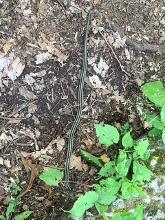
Coming up to Wapiti shelter at lunchtime I spotted a 6 foot long black snake disappearing in to the undergrowth besides the trail (since informed it’s not poisonous). If you zoom in to the photo below it’s behind the tree trunk.
The afternoon featured occasional showers to keep the mud nice and slippy so I was glad to get in to the shelter a little after 007 at about 5. Once I was at the shelter a steady stream of people continued to arrive - unfortunately for them the shelter only held six.
Day 67: Pearisburg
Monday 23rd May
8.8 miles
24,429 steps
132 floors
The first 6 miles down to Pearisburg were pretty easy, a little muddy but nothing too steep. However from that point onwards was steeply downhill down slick mud trails. It wasn’t at all fun and really slowed down progress as every time I tried to speed up my feet would slip out from under me.
Arriving in town on the other hand was great, a local gave us a lift from the trail saving a pointless mile, the motel is clean but basic and there’s a supermarket opposite.
As for tonight I’m sharing a room with fellow Brit 007 and Sneaky Pete.
Milage so far: 634.6
Nope I haven’t forgotten the photos again this week, it just hasn’t been very interesting.